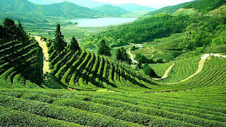
SLAMET MOUNT, Central Java Tourism ( Indonesia)
Mount Slamet (3,428 meters above sea level ) is a cone volcano located on the island of Java , Indonesia . Mount Slamet is located between 5 districts, namely Brebes , Banyumas , Purbalingga , Tegal , and Pemalang , Central Java. Mount Slamet is the highest mountain in Central Java and the second highest in Java after Mount Semeru . Crater IV is the last crater that is still active until now, and last active until the level of standby medio-2009.
 |
| Mount Slamet View |
Geology
As with other volcanoes on Java Island, Mount Slamet was formed due to Indo-Australian Plate subduction on the Eurasian Plate in the south of Java Island. Cracks in the plates open the lava path to the surface. Records of eruptions are known since the 19th century. The mountain is active and often has small-scale eruptions. The last activity was in May 2009 and until June still continued to release lava incandescent. [1] Earlier it was recorded to erupt in 1999.
March 2014 Mount Slamet shows its activities and status to Be Waspada. Based on the PVMBG data, the volcanic activity of Mount Slamet is still fluctuating. After the occurrence of an earthquake eruption up to 171 times on Friday March 14, 2014 from 00:00 to 12:00 pm, at the same time duration, recorded as many as 57 times the earthquake eruption. Also recorded 51 times a gust. Visual monitoring, a thick puff of white smoke still comes from the crater of the mountain to the east up to 1 km. [2]
Historical record
 |
| Old Photo of Mount Slamet |
The Dutch historian J. Noorduyn theorizes that the name "Slamet" is relatively new, ie after the entry of Islam into Java(the word is an Arabic loan). He argues that the so-called Gunung Agung in the Sundanese manuscript of Bujangga Manik adventure is Mount Slamet, based on the exposure of the mentioned location [3] .
Ecology
This mountain has a forest area of Dipterocarp Hill , Upper Dipterocarp forest , Montana forest , and Ericaceous Forest or mountain forest .
The Legend of Mount Slamet
 |
| Mount Slamet when it eruputs |
Hiking trail
The standard climbing route is from Blambangan, Kutabawa Village, Karangreja Subdistrict , Purbalingga . Other popular routes are from Baturraden and from Gambuhan Village, Jurangmangu Village and Gunungsari Village in Pemalang District. In addition there is also a path that was recently inaugurated in 2013, namely the Dhipajaya line located in Pemalang District.
 |
| Hiking trails Mount Slamet |
Other climbing route is through the object of hot water bath Guci , Tegal regency. Although steep, this route provides the best scenery. Guci area can be reached from Slawi to Tuwel area through Lebaksiu.


Comments
Post a Comment